Blackledge Falls Coal-Maker House

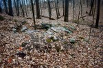
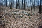
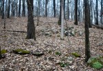
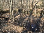
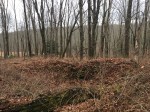
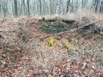
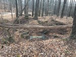
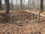
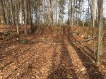
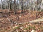
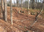
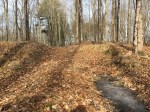
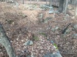
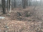
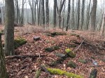
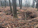
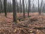
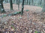
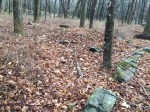
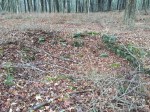
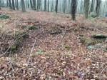
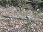
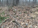
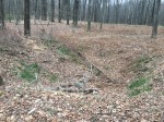
Walk around the woods in the right part of Glastonbury and if you know what you’re looking for, you’ll see large, flat circles that interrupt the natural landscape. These are the remains of charcoal heaths, a once thriving industry in Connecticut that dates back roughly 200 years.

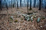
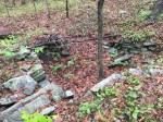
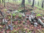
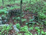
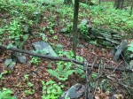
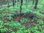
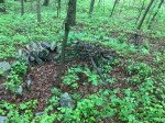
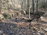
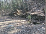
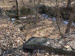
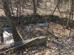
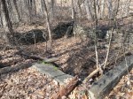
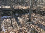
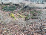
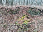
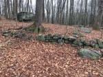
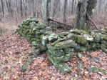
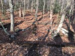
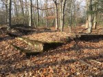
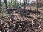
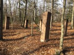
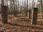
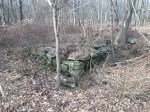
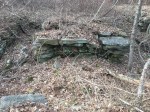
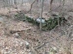
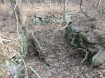
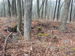
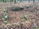
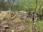
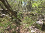
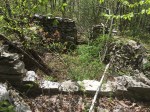
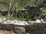
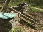
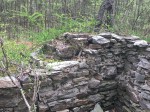
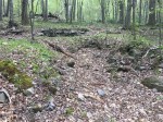
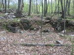
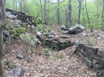
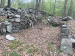
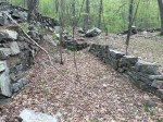
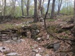
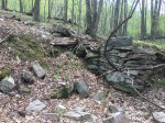
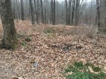
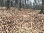
Blackledge Falls Park features at least six of these hearths — one of which the trail up to the falls crosses directly over — as well as the remains of a collier’s home, or the coal-maker. The house was built into the side of a hill, nearby to a stream and old path. The chimney has since collapsed over along with some of the retaining walls, though the general shape of the foundation can still be made out.

There are four hearths in the immediate vicinity of the house ruins. The house is located on a path that traveled from what is now Gay City State Park, through Blackledge Falls and down to Marlborough, used by colliers to transport coal. Lidar images of the area shows numerous charcoal hearths dotting the area.

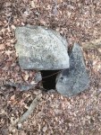
In August 2019, the Historical Society of Glastonbury hosted an archaeological dig of the area and found an axe head and pipe stem, among other unnamed objects. There are plans for excavations to be continued in the near future.

All information via the Hartford Courant.

Related – Blackledge Falls Dam

Cotton Hollow Mill Houses

SAVE THE COTTON HOLLOW MILL

Here’s a simple geography lesson: Cotton Hollow is located in South Glastonbury. That’s an easy conclusion nearly anyone could come to by looking at a map or having a general sense of the land. But long ago, Cotton Hollow and South Glastonbury were different worlds – literally.

The two settlements were once separate by a large fence and gate, manned by a watchman who closed the gate each night at nine o’clock. Anyone left on the wrong side needed to cross Roaring Brook and walk all the way around to get back home. The gate was there for a reason: The two sides were rivals. According to an undated story in the Hartford Times, the kids of South Glastonbury had a dance in the old Academy Hall and didn’t invite the Hollowites. The latter showed up and crashed the party, starting a small skirmish outside.

The people that worked in the mills of Cotton Hollow lived in houses around the mills. There were some located on Cotton Hollow Road that were abandoned and eventually demolished. At one point in time, a bridge crossed over the stream to three houses – the foundations of which can still be seen.

The homes were all located nearby to each other, sitting exactly 35 feet apart. They were all square with stone foundations. One of the foundations has an old well inside whereas the other two have a filled-in well sitting next to it. Also nearby to the forgotten homes are old foundations built partially into the wall, possible that of an old barn or shed.

The footings to the old bridge that crossed Roaring Brook are located right next to the foundations as is the marker to the famous Eunice Cobb Stocking Gunpowder Mill.

J. Cooley/S. Franois House Ruins

Located within the Coop Sawmill hamlet, the J. Cooley/S. Franois House is one of the (relatively) younger house ruins along Coop Road. The foundation lacks a center chimney, which most of the old homes on Coop Road had. A center chimney typically indicates the house was built around the colonial period (pre-1776) in America.

The foundation is now located in a thicket with only part of one of the four sides of the foundation not yet collapsed. Just south of the house, parts of the old barn foundation can be seen with what looks like a small retaining wall of rocks in the ground.

The house appears on an 1855 Map of Glastonbury as “S. Franois” listed as the owner while an 1874 map of the town lists “J. Cooley.” Aerial photos from the 1930’s show the house still standing.

E. Shurtleff House Ruins

At the point where the Shenipsit Trail intersects with Coop Road, an old house foundation hides in the thickets. According to an 1874 map of Glastonbury, the house was owned by E. Shurtleff. It is not clear when the house was abandoned.

The foundation of the house is under a thicket, though a collapsed center chimney and the foundation is still mostly visible. Nearby is the foundation of another building, likely a barn or shed.

Wooldridge Homestead

At the point where old and new meet, the Wooldridge Homestead has certainly leaned towards old.

The house was located where Old Coop Road and new Coop Road meet. The house was located on the corner while a barn was set farther back from the road. They have been abandoned for a long time since neither can be seen on aerial photographs from 1934.

From Old Coop Road, there’s a small driveway leading up to the house ruins. The foundation has collapsed and is mostly covered in grass and plants were few stones visible. The remains of the center chimney are nothing but a heap of rocks on one side of the hole. There’s a break in the foundation facing Coop Road, potentially a doorway into the old basement.

The barn was large and only partially dug into the ground on the north side. Some of the stones can still be seen lining the edges.

An 1874 map of Glastonbury says the home was owned by Wooldridge – just Wooldridge. However, according to town land records, James W Wooldridge and Elizabeth Sarah Leigh Wooldridge acquired a deed from Read Matthew P on Dec. 17, 1870. That was likely the sale of this very house.

Nearby:

Old New London Turnpike Gas Station

At the top of where Old New London Turnpike climbs a hill, there are old concrete ruins in the woods. While its not certain, they are likely that of an old gas station, probably one of the first in town.

There are five concrete pillars located pretty close to each other and next to a concrete foundation. The concrete foundation has three steps going up facing the road, likely the entrance into the building. There are piles of rubble on two corners of the foundation.

On an aerial photo from 1934, there doesn’t appear to be an structure even here.

Nearby:

I. Goslee House

Just beyond the intersection of Old Hebron Ave and Old Coop Road, the ruins of an ancient house sit under a thicket, though when the house was built, neither road included the “old”. As of 1934, the house still stood (seen below) but it was likely torn down or abandoned shortly after since there’s a fairly large tree growing out of the foundation.

This map claims the house was built in 1720 and in 1874, the house was owned by I. Goslee.

The foundation is still intact with the base of the center chimney visible. Across the street is a large barn, likely owned by I. Goslee as well. There are also a pair of smaller foundations behind the house. Between the house and rockwall was a well.

Nearby:

J.A. Gallopp House Ruins

It’s hard to tell how old a foundation in the woods has been abandoned. But some make it easy to distinguish between “old” and “really old.” Take the J.A. Gallopp House ruins on Coop Road. The foundation has mostly filled in with just a bump in the middle where the chimney once stood. On the north side is a filled-in well. But the most telling sign are the multiple large trees growing out of the foundation. For anything to even start growing, the entire structure needed to be gone and the foundation needed to be filled in. The fact that multiple trees could root and grow to a decent size shows the site has been abandoned for many decades.

Nearby to the house foundation across a trail is a smaller foundation, likely that of a barn or shed.

The house is not listed on an 1874 map of Glastonbury but it is on a 1855 map of Glastonbury. The latter lists it under the name JA Gallopp.

S. Stevens Homestead Ruins

The ruins of an old homestead can be seen just on Diamond Lake, right on a sharp corner.

The old driveway comes up the backside of the hill to the top, where what was likely the house stood. The foundation is still there in decent shape, though it seems a bit small to be a house. But it has stairs going down to a basement as well as stairs that lead to the top of the foundation.

On the side of the hill are a few old foundations of barns. One foundation is fairly large and long. The stonework around the edges is still in good condition and the shape can still be seen. The other foundation is built more dilapidated but still rather visible.

According to a map of Glastonbury from 1874, the house was occupied by S. Stevens. No buildings are visible on aerial photos from 1934, meaning the house was likely abandoned years before that.


N. Hale House Ruins

On the very northern border of Glastonbury, the ruins of an old house are collapsed around mountain biking trails in the Case Mountain recreation area off Line Street.

The house was owned by N. Hale at one point according to an 1874 map of Glastonbury. It appears the house was abandoned long before aerial photos came around in 1934 and few traces of the house even exist. The stone foundation has completely collapsed and been buried beneath leaves and dirt, with only a few traces still remaining. If you look closely enough, a small driveway leads up to the house from Line Street.