Eastbury Pond

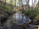
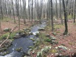
Although it has become a popular place for parents to take their children during summer vacation, Eastbury Pond was once powered the largest of three mills (Shoddy Mill upstream, Hodge’s Pond downstream) along a 1.5-mile stretch of Roaring Brook in the small village of Eastbury – which included a church, cemetery, schoolhouse and post office.

The mill was built in 1840 by the Roaring Brook Manufacturing Company as a cotton and woolen mill owned by William C. Sparks. However, it changed hands in 1862 when Edwin Crosby and Sereno Hubbard purchased it. The mill made a big profit during the Civil War and it was enlarged to keep up with demand. After the death of Hubbard, Crosby took full control and the mill became known as the Crosby Manufacturing Company.

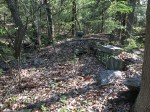
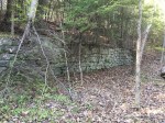
In 1928, it became Angus Park Manufacturing, producing heavy woolen goods with around 150 workers. In 2015, the remaining parts of the mill built in 1860 were destroyed by a massive fire, removing one of the final traces of the manufacturing history in the hollow.

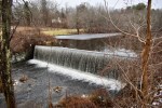
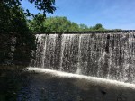
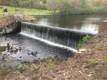
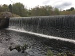
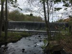
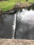
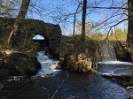
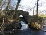
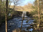
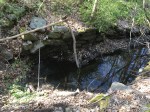
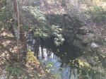
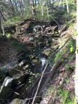
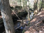
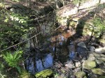
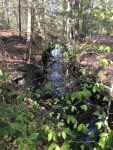
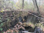
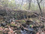
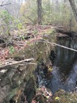
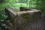
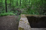
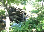
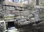
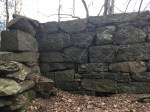
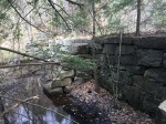
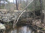
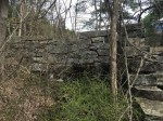
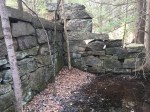
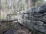
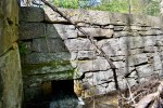
Now, the last glimpse of that era is the large stone dam that holds back the water of Eastbury Pond. The pond is pretty different from the days of the mill as dirt walkways have been built to separate swimming areas from fishing areas. With the development of the area as a recreation center, the sluiceway has been replaced with the entrance driveway.

Eastbury Pond is one of the few places that found a new life after the mill it powered disappeared. Most dams simply crumble until they break or are removed for ecological reasons. Luckily, the dam should stand for a long time as it gives generations of kids a way to visit the beach without leaving the comforts of town.

Smut Pond

DISCLAIMER: While Smut Pond and its dam are owned by the town of Glastonbury, the surrounding area is private property. If you visit, please respect the local landowners and stay on the town-owned easement. The entire south bank of Roaring Brook from Woodland Road to Matson Hill Open Space (including Smut Dam and Flat Rock) as well as the north bank is private property. Trespassing is a criminal offense and after speaking with landowners will result in arrest.

Of the dams that still stand in Glastonbury, few have been built with the same craftsmanship and beauty as Smut Pond. Renovated in the 1970’s, the 15-foot high dam features a curved top with a remarkable arch sluiceway.

Depending on the time of year, water flows over the top, creating a picturesque waterfall. On the northern side, the arched sluicegate remains fully-functional. It empties into a little pool area, where some of it flows into the still-intact sluiceway. Sticks and other garbage have blocked up the flow of water, but the retaining walls are still visible, and can be followed all the way back to where it reconnects with Roaring Brook.

The sluiceway forms a small island, where some of the foundation of the mill still remains along with scrap metal scattered on the ground. There’s also some foundations and wells that can still be seen from the surround buildings.

The Hartford Courant details the history of the site well. The site was first occupied by a forge, which gives the area the name since the constant burning covered the entire area in black soot. Roaring Brook was dammed at this point as early as the 1700’s. The location changed hands around 1850 by the Hartford Manufacturing Company – the same company that owned the mill in Cotton Hollow.

Under the new ownership, two new mills were built and operated through the 19th century. Eventually, the JT Slocumb Company – who ran the Hopewell Mill upstream – gave the property to the town, who still owns it today.

Shoddy Mill Pond

In an area teeming with history along Old Hebron Avenue, Shoddy Mill Pond is a hidden feature.

The dam itself sits about 50 yards back upstream from the old road. It stretches about 30 feet across while standing around four feet tall. It is mostly made of large stones, however it appears to have been topped with concrete at one point. Most of the stones and concrete are covered with moss, which gives off a very eerie feeling around it.

The eastern side of the dam angles in towards the pond. It appears a sluicegate may have once stood here, based on the positioning of the rocks and the terrain of the dirt. Stones seem to line a depression in the Earth that travels away from the dam, parallel to the stream. The trench used to carry under Old Hebron Avenue before re-connected with Roaring Brook farther downstream, but the construction of new Hebron Avenue has buried much of it.

Some records indicate that a blacksmith shop was in the area and likely used the water from the dam.

Just downstream, before the old bridge, is a low dam. On either side are concrete supports, about four feet tall, and then a short concrete structure that sticks out into the water. It only sits about a foot above the water and is in rather dire condition.


Buckingham Park Dams

The Buckingham section of town is one of the most dense collection of historical ruins in Glastonbury and Buckingham Park is no exception. There are three small dams within the confines of the park, all on top of each other.

The lower dam is the most visible as the trail crosses right over it, which has caused erosion over the years. It’s small, standing no more than a few feet high but stretching nearly 20 yards across. It is mostly made of dirt, although there are some large rocks where the water now runs. Next to this is a U-shaped concrete structure which served as a sluicegate. There’s a pipe at the bottom and the water flow appears to have been controlled by a board placed in groves at the opening. This same structure is also found at JB Williams Park.

The middle dam is located on the same pond as the lower dam, although it has since been broken. It is the smallest of the three, as it is just as tall as the others but only stretches a few feet. It is completely earthen and does not have a sluicegate like the other two. However, it does have a handful of pipes sticking out of it.

The upper dam is about the same size as the lower dam, although it had the largest pond of the three. It is long, short and made of dirt. It also has the sluicegate, although one side has since cracked. It no longer holds water as it has been broken like the others.

The history of these dams is pretty muddy. While they were likely used to just hold water, as they aren’t big enough to power a mill, it’s unclear why three dams were needed or what the water was used for. There are no records of anything in this specific area and there are no remains of anything around them. The middle and upper dams still held water according to aerial photos from the 1960’s, while the lower dam held until the 1990’s.

Pratt’s Forge – Glastonbury Anchor Works

SIGN THE PETITION TO SAVE THE COTTON HOLLOW MILL

The first site within Cotton Hollow is Pratt’s Forge, also known as Glastonbury Anchor Works. The remains represent the history of the location but it also represents the lost industry of Glastonbury: Shipbuilding.

With the Connecticut River as it’s west-most boundary, Glastonbury was one of the biggest shipbuilding towns in the state, launching boats from Log Landing in South Glastonbury in the area of Pease Lane. Local legend states that the industry died when the railroad came to Connecticut and rail bridges were built across the Connecticut River, therefore making it impossible for the masted ships to traverse the waterway.

While the site is best known for its anchors, it originally began as a smaller forge that produced smaller goods such as farm equipment. The forge first operated farther downstream (where the remains can still be seen) but when the Hartford Manufacturing Company built its mills and dams, the forge relocated to a new spot.

Eventually, it became an anchor forge with a handful owners before George Pratt – once a worker in the forge itself – purchased it. It produced anchors for much of the latter half of the 1800’s but by 1893, the building was in disrepair.

The remains of Glastonbury Anchor Works are still quite visible. The dam, while now broken, still stands on a large rock with Roaring Brook cutting through it. The sluicegate can still be seen on the south bank, although it no longer functions. Much of the foundation of the building can still be seen as well, as large stones line the stream and parts of the sluiceway remain where the water was released back into the brook.

The bank is also covered with slag, a metal byproduct created during the iron refinery process. If you look close enough, you can also find small pieces of charcoal used to mold the iron as well.

Pratt’s Forge is located directly behind the Grange Pool. Park at the preserve off Hopewell Road and follow the trial left.

PHOTOS:

Coop Sawmill

Once the center of a small hamlet in the northeast Glastonbury, Coop Sawmill – like much of the land around Buckingham Reservoir – has faded into history.

Coop Sawmill is likely one of the oldest industries in Glastonbury, as it possibly began operating during colonial times and ran at least until 1874.

The mill probably wasn’t very big, although large enough to support a handful of families. In the immediate vicinity of the mill are foundations of three old houses. Two likely weren’t farmers based on the fact that one foundation is located on the side of a rocky slope, while the other abuts Roaring Brook. Farming around either of these houses would be next to impossible.

The dam used to power the mill can still be seen. It appears to have been broken in the middle, although the space in the middle could’ve been where the waterwheel turned. The dam is a mix of stone and dirt and looks like a large stonewall across a stream in its current state.

Just downstream from the dam are some stone foundations which is likely held the mill itself up. Besides these and a few iron scraps laying around, there aren’t many remains of the mill that can still be seen.

Coop Road runs just downstream from the dam, which connected it to Glastonbury, Bolton and Manchester. The remains of an old bridge that carried the road over Roaring Brook are still visible.

Related:

PHOTOS:


Hodge’s Pond

Hodge’s Pond was still standing up to a few years ago, but broke during a period of heavy rain. The town, obviously having no use for the dam anymore, decided they weren’t going to fix it. Most of the dam is still standing, as the break was rather small in the eastern portion of it. On the side that still stands, a waterwheel towers in the trees, with an old sluicegate still seen nearby.

Next to the break, a stone wall is built into the side of the small hill, likely a wall of the mill that once harnessed its power with the dam. There’s a depression in the ground nearby with some rocks lining it, but it doesn’t seem like it’s in the right spot to be a sluiceway.

According to Nassahegon Notes (now defunct), the dam was built by John Hodge around 1769, and a map of Glastonbury from 1857 states that a paper mill was located there, possibly called Hills & Finley at the time.

The dam is easy to see, especially in the winter time. It’s located just off Manchester Road in the area of the Quarry Road intersection and nearby bridge. Along Manchester Road are some low stones in the ground, likely part of the support for the dam.

Shoddy Mill Preserve

Shoddy Mill was built in the 1840’s, around the same time as other textile mills in town such as Crosby Manufacturing (Located at Eastbury Pond) and the Hopewell Mill. As its name suggests, it produced shoddy, a recycled wool product that was cheap. According to this article by the Hartford Courant, workers from the Crosby Manufacturing Company would travel up to Shoddy Mill to “grind woolen waste of different colors into a dark blue product from which a woolen yarn was spun.” The mill closed in 1906 and the pond was converted to tenement housing. The town purchased the property in the late 60’s to preserve it for open space.

Today, while the mill has vanished, the huge dam can still be seen. It spans over 50 yards and stands over 10 feet high. While broken on its eastern-most side, it remains one of the most beautiful dams in town. The masonry is still in excellent condition and is a great tribute to Yankee craftsmanship. A few large nails stick out of the top and likely help to hold the stones in place. There are a few perpendicular supports that allow easy access to the bottom of the dam where its size and masonry can truly be appreciated.

The sluicegate is still functioning and a solid flow can be seen coming through it if the water is high enough. Stones still line the flume before it re-joins with the main stream. On the opposite bank, there’s some metal and stonework that can be seen, likely the ruins of a smaller building connected to the larger mill.

The mill pond still exists thanks to beavers, who have built a dam across the breached section.

Related: