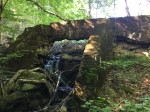
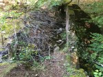
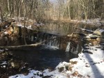
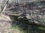
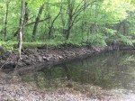
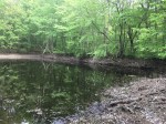
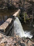
In the Meshomasic Forest in East Glastonbury, just off the Old New London Turnpike sits the remains of the East Hartford Water Company’s dam.
The dam sits perched at the top of Dark Hollow, which according to legend was where a stagecoach went off the road, killing everybody on board. The dam has met a similar fate. The concrete structure has completely breached, leaving the middle wide open. The rest of the dam still stands for now, including the sides, top and most of the back.
It appears to have been made of a weak concrete with rocks mixed in. It was flat across with two supports extending out perpendicular. Despite being a reservoir, there’s no evidence of pipes anything to pump the water out. There are only a few small roads leading into the pond.
While the dam has been breached, beavers found it a suitable spot to build their own dam and kept the pond full.
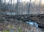
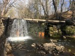
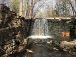
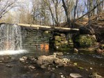
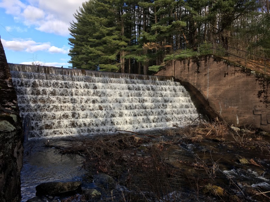
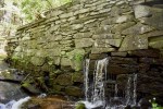
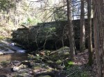
When Buckingham Reservoir was built in 1914, a massive earthen dam was built in the path of Roaring Brook. The water was diverted towards spillway, where a new current for the water was created. The original stream was – and still is – used to release excess water.
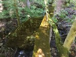
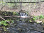
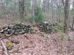
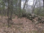
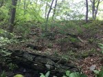
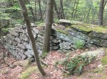
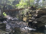
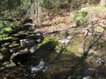
However, not far from the release pipes is a dam, seemingly counter-productive if the goal is to get rid of water. However, it is the remains of a sawmill built long before the reservoir ever existed.
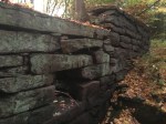
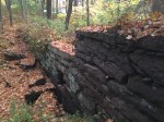
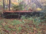
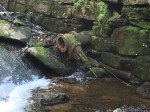
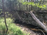
The Sturgeon Sawmill dam is two-parts: One – the larger portion – looks like a built-up stone wall spanning along a the side of a pond. The other is the spillway where the water flows over which looks more like a traditional dam. However, it’s just two feet high and 10 feet wide, one of the smallest in town.
The remains from the sawmill itself have long disappeared as the dam sits alone in the woods.
According to “The Memorial History of Hartford County” by J. Hammond Trumbull, published in 1886, “About a mile farther down (From Coop Sawmill) are the vestiges of another saw-mill.” This sawmill is in fact a mile downstream from Coop Sawmill despite being unidentified. There are no other dams from here to Shoddy Mill Pond and any other dams upstream would be beneath the reservoir.
The name “Sturgeon Sawmill” comes from Roaring Brook’s original name: Sturgeon River.
When it comes to industrial history in Cotton Hollow, there’s no question the ruins of the Hartford Manufacturing Company are the first things that come to mind. However, smaller, local industry has thrived as well.
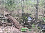
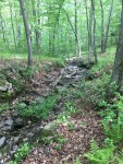
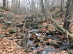
In lower Cotton Hollow, Roaring Brook splits to create an island, once a park that was the terminus of the town trolley. The northern part of the stream still flows strong but the southern part has mostly filled in and any water is mostly stagnant.
With the stream in said state, it’s difficult to imagine it even moving, let alone being used as a water source. However, it was once the site of an old sawmill.
The dam for the mill can still be seen, but barely. It has degraded to a point where it’s difficult to spot when leaves are on the trees and even in the non-foliage months it can be mistaken for a pile of rocks. It stands no more than a foot or two high presently and only a few feet wide. It stops at the brook and there’s no sign of the stone ever crossing to the other side to harness the water.
While not very big, it is the last reminder of the industry that once bustled throughout Cotton Hollow and one of the final dams once located on Roaring Brook.
As mills in New England progressed from simple pre-Revolutionary saw and grist mills to large, stone factories, the latter were often built on the same site as the former. This usually happened because the watersource was good or mills were upgraded over the years. However, a pair of dams in the highlands of East Glastonbury tell a different story.
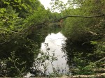
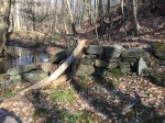
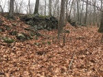
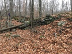
Just east of Diamond Lake is a mostly-dry pond created by a large dam, made of both stone and earth. It has the shape of a reservoir dam: Tall and wide but triangular as well, giving it more support than a tall and narrow stone dam such as Shoddy Mill or Smut Pond. There’s more reason to believe it was a reservoir as there’s no evidence of a mill in the area. Only a crude spillway can still be seen which likely prevented the pond from washing out the dam.
Although mostly made of dirt, large stones can be seen along the back side of the dam as well as the very bottom. While there’s no visible breach, it no longer holds much water back, as the pond has dramatically shrunk. However, this has revealed a piece of history that would not be visible with the full pond.
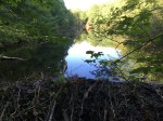
This large dam was not the first dam in the area. In fact, it wasn’t the first dam on this pond. An earlier dam can be seen 30 yards behind the dam, this one much smaller and made of stone. It appears to have been the water source of an ancient mill, although nearly all vestiges of it have completely vanished. When the larger dam was built, the resulting pond flooded the smaller dam and whatever may have remained of the mill.
Today, both dams can still be seen although they have long since become obsolete. Records of anything in this are are non-existent but part of the charm of lost history is the element of mystery. Even if you can’t know what was here, it can still be appreciated in its modern-day state.
When discussing lost history, forgotten homes, mills and dams are often brought up. However, names can be lost as well. The area known as Addison once went by another name: Eagleville. It’s name came from the Eagle Manufacturing Company which produced woolen goods, including uniforms for the Union Army in the Civil War.
Located at the corner of Hebron Avenue and Mill Street, the business was sold to a young man by the name of Addison Clark in 1855. Five years later, Glastenbury Knitting Company (Now Addison Mill Apartments) was built upstream and a year after Clark’s death in 1897, the surrounding village was named Addison in his honor.
Addison Mill and dam still stands, now apartments but not much is left of the Eagle Mills, save for a few vestiges.
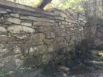
The biggest reminder of the past is a hulking dam just off Mill Street. It is made of large, rectangular stones with minimal water leaking through the middle, a sign that shows it remains in good condition. It sits over 20 feet high and spans a deep ravine which Salmon Brook flows through. Much of the area around the dam has been changed with the mill no longer standing but the dam itself is rather untouched.
There are what appear to be some reinforcements to the dam on the south side, as there is a second layer of stone. On the North side, a wall of stone abuts it at a 90 degree angle as a retaining wall. While the sluiceway doesn’t come up to the dam anymore, it can still be seen about 20 yards downstream from the dam under some thickets. It runs for 1o feet or so before disappearing into the road.
Along the north side, a piece has been removed in order to keep water flowing through and the height of the mill pond down. There isn’t much of a mill pond. If you didn’t know a dam was there, it would be easy to mistake it for a wide part of the brook as it flows through a narrow gully.
The dam is probably on private property, so venturing down to it is discouraged although it can be seen pretty easily from the road, especially in the non-foliage months. At worst, you can park your car at the lot across the street and look from the guardrail.
As time passes and we drift further from the age of waterpower and industry in Glastonbury, the dams which harnessed the water for the many mills in town lose their purpose and are slowly reclaimed by the woods. Some dams are forgotten about and breach naturally, such as Hodge’s Pond. Others, like the dams at Cotton Hollow, are removed to restore the health of the waterways.
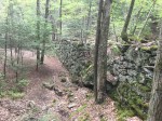
At their peak, the dams at Cotton Hollow were unrivaled in their size. There was a 60-foot and 25-foot, both stone, located right next to each other. The 25 foot dam would likely have been one of the three tallest dams in town, with Buckingham Reservoir and Hollister Grist Mill both close. However, the 60-footer was unmatched, nearly twice the height of the next tallest. The story goes that the 60-foot dam was built on its own, but there would be so much water rushing over the top that they decided to build the 25-foot to harness the overflowing water.
In the early 1900’s, the sheer size of the larger dam meant it needed to be removed or replaced. A 100-foot dam was proposed at one point but was quickly shot down. Leaving no other option, the 60-foot dam was removed on May 10, 1904. It is unknown how long the smaller dam survived after that but it would eventually meet the same fate.
Fortunately, the dams were not full removed and their remnants can still be seen.
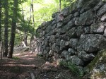
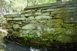
Beginning with the 25-foot dam, much of the dam still stands. It sits just across the stream from the cotton mill ruins, towering over those standing next to it. Unlike the dams at Shoddy Mill and Smut Pond, it is not stunning masonry. The stones are rough and misshapen, meaning they don’t appear to completely fit together.
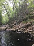
The dam slopes down like a staircase as it approaches the water, allowing visitors to climb to the top. Looking upstream with the keen eye, the vestiges of the larger 60-foot dam are visible.
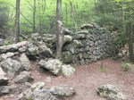
The dam was built in between two rock ledges where the water squeezes through a narrow gap. The remains are located on the south side in a column-like formation. At the top, the rocks are still mostly in place and it’s easy to see the dam. But descending towards the water, the rocks become more loose and could be mistaken for a natural rock formation. On the opposite bank, the only remains are metal posts pounded into the cliff face to hold the dam in place long ago.
This dam would’ve flooded much of the area in Upper Cotton Hollow, showing that not all dam removals are a negative. Dams that size are too large to save for history, but that doesn’t mean they are lost forever. There are over 50 dams in Glastonbury, ~27 on Roaring Brook and it’s tributaries alone. Despite such a high number, few live on with the same legacy as Cotton Hollow’s.
As the years go on and towns evolve from bustling industrial hubs to sprawling suburbs, it’s no surprise many of the vestiges that remain from earlier days can slowly fade into the woods. In Glastonbury, there’s more than a couple of examples, whether it be Cotton Hollow, Shoddy Mill Pond or Coop Sawmill, to name a few. In fact, it’s more likely to find an old dam sitting in the middle of the woods than in somebody’s backyard.
The Shenipsit Dam is unique. Not only is it located in the middle of the woods but there’s nothing around to suggest anything was even here except the hulking dam. Located on Birch Mountain, the Shenipsit Trail travels through the dam. Yes, not over it, through it.
The true date of the dam is unknown but mother nature has long been in the process of reclaiming it. Despite a hulking size, one of the largest in town, it sits in quite the sad state. It sags heavily towards the middle and appears to have been broken for decades now. The middle of the dam has been carved out from years of hiking, biking and general erosion from the Shenipsit Trail. Trees have also done their fair share of damage; As they grow on the dam, the roots displace the rocks that once held it together as they grow with the tree.
The middle has certainly been degraded more than the edges. On one side, large boulders still hold their place, supplemented by smaller rocks that better resemble a dam. On the opposite side, the rocks stand a little taller than the middle. Without this, it would be difficult to even recognize this as a trace of history.
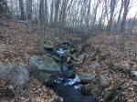
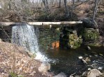
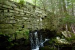
Is a dam still a dam even if water no longer flows through it? Or does it just become a wall at that point? Well, this is the case at Woodland Dam.
In the shadow of Roaring Brook, Woodland Dam is nestled just off the unique intersection of Coldbrook Rd and Woodland Street. The real name of the dam is unknown. An 1874 map of Glastonbury lists an “E. Hodge Est.” in it’s location, but Hodge’s Dam would create confusion with nearby Hodge’s Pond. It is located on an unnamed stream, which does not help and while Coldbrook Rd is nearby, that would also conflict with the Cold Brook Reservoir up the road. Therefore, Woodland Dam is the only name that fits.
The dam is decent-sized, standing about six feet tall while stretching 20 yards wide or so. It remains in good condition, with all the masonry still intact and standing. The sluicegate is a square right in the middle of the dam and with the stream dried up, you can look right through it, something that can’t be said about most other dams considering they’re typically at the bottom and have water running through them.
My visit was in October, so the drought could have contributed to the lack of water. Even if the water was rushing, there appears to be no mill pond anymore with the permanently-opened sluicegate. The dam continues on the south bank for about ten feet before turning slightly and ending.
The sluiceway has now become part of the stream, although some of the stones that once lined it can still be seen. On top, some screws that hold the stones in place stick up from the top which indicates that they may have fallen at some point over the years.
Woodland Dam is a cool site to visit when the water is low because it’s rare you can explore both sides of a dam. It won’t be a very long visit, however, it’s located in a spot with plenty of other dams nearby and definitely worth the quick trip to see.
Buckingham Reservoir: Built by the Cheney Family in 1924 for their silk mills, the reservoir is now used by the Manchester Water Company.
Chalker Hill Dam: A small dam located on private property. Built after the 1930’s.
Chestnut Hill Reservoir: Once one of four main reservoirs in town, it has since been greatly downsized and is now located in a residential area without any access points. Vestiges still remain from the reservoir, including a tall concrete structure.
Coldbrook Reservoir: Another one of the four main reservoirs in town, Coldbrook Reservoir has recently been purchased by the Town of Glastonbury from the MDC but fences still surround it, making it difficult to access.
Glastonbury hoping to purchase 700+ acres of MDC land for $15 million. On a video tour of Cold Brook. Here's a clip. pic.twitter.com/LVq4ZcPzcn
Fawn Dams: Just west of the intersection of Hopewell Rd and Chestnut Hill Rd are two small dams in the woods.
Grindle Brook Mill: Located in South Glastonbury, this dam likely powered grist mills that crushed stone from the nearby quarries in the area. This dam can be seen from Main Street across from Great Pond Road.
Gideon Welles Dam: A small stone dam located in the woods behind Gideon Welles School.
Hazel Pond Dam: A long dam located behind the Wassuc Schoolhouse on Wassuc Road. The purpose of this dam is unknown and it is located on private property.
JB Williams Soap Factory: The company that started Lectric Shave and was one of the largest soap companies in the world is now apartments, much like Addison Mill. You can see the dam and the rest of the mill here.
Nayaug Spar Mill: The dam has mostly been removed, but remains can still be seen from the Water Street bridge. Any ruins are located on private property.
Old Keeney Reservoir: Once one of four reservoirs in town, the dam was dismantled in the mid-1900’s. A large earthen embankment still remains along with a few concrete structures but thick underbrush and a newly-built beaver dam at the break make the area difficult to navigate for photos.
The earthen dam.
The back of the dam.
A concrete structure.
The access road in.
Red Hill Dam: Located in the woods at the end of the Riverview Road cul-de-sac, information on this dam is unknown. It is located near a residential area and cannot be accessed.
Roaring Brook Paper Company: The ruins of Buck’s Corner Dam are located on private property, therefore inaccessible. However, the dam can still be seen from New London Turnpike, especially during non-foliage months and on satellite maps.
Roser’s Tannery: Located just off New London Turnpike, Roser’s Tannery is in the process of being converted into apartments. The dam has been mostly rebuilt.
Smith Dam: This dam is located in the woods of the Buttonball neighborhood, but is likely unaccessible.
Stanley Dam: Located in a ravine off of Stanley Drive, the dam is still mostly intact but the pond is gone. It’s technically situated on open space, but access is limited.
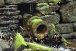
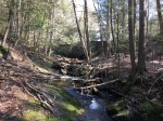
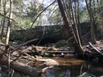
Upper Addison Dam: Located in the woods behind Smith Middle School, there was a small dam in a narrow ravine. There are few remnants of the dam aside from some pieces of cut stone, brick and mortar along with a few pipes. The site is also complicated by debris cut under the overhead power lines along with a beaver dam on the site.
The entire site.
Old pipes.
A cut stone.
Bricks are visible next to the stream.
Weir Sawmill: Two dams are located at this site, once an old sawmill. However it is located on a homeowner’s property and cannot be accessed. The upper dam can still be seen in the non-foliage months from Weir Street.
Wood Pond Dam: Just up the road from Chestnut Hill Reservoir, there is a small earthen dam on one end.
If you can access any of these sites, have information on any of these dams or know of any not mentioned, use the CONTACT button on the top of the page.
To see where these dams are located, check out the map below:
During the 19th Century, fire presented the biggest threat to mills in the US. When Frank Glazier took over the Hopewell Mill, he built an innovative fire suppression system that was way ahead of its time.
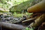
Since Slocumb Dam already being used to power the factory, he needed to find a new source of water. He decided to build Slab Gut Brook Dam a quarter mile away from his mill.
The dam was made of granite and stood 15 feet tall and spanned 20 yards on a large rock slab. It has since breached, but the portion still standing is in good shape. Pipes can still be seen running from the dam down to the mill. Since it was up high on a hill, water could be drawn down with gravity.
Eventually, the mill closed and Slab Gut Brook Dam was forgotten. Now, it stands as a reminder of one of the town’s earliest fire departments.
A pipe sticking out of the dam.
The backside of the dam.
The break in the dam.
Where the dam used to connect on the eastern side of the brook.


